
XGRIDS is a technology company specializing in high-precision spatial computing solutions—combining handheld LiDAR scanners, panoramic vision systems, AI-driven multi-SLAM algorithms and advanced 3D Gaussian Splatting (3DGS) software—to enable rapid, photo-realistic 3D reconstruction and digital twin capture of real-world environments.
Applications in Industries


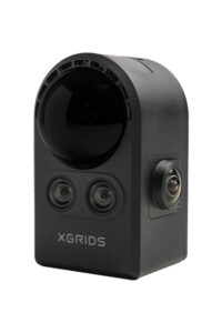 PortalCam
The First True Spatial Camera
PortalCam, world’s first handheld device built for seamless reality capture. Leveraging advanced Gaussian splatting technology, the PortalCam rapidly produces detailed, interactive 3D environments with minimal user effort.
Equipped with LiDAR, a four-camera array, and automated processing, the device creates photorealistic spatial models that can be explored, edited, and shared across multiple platforms. Its versatility spans industries—from real estate virtual tours to film production, and even personal occasions like weddings and birthdays.
Weighing under 900g and supported by XGRIDS LCC for straightforward software integration, the PortalCam offers a portable, efficient, and user-friendly solution for professional-grade 3D capture in any setting.
ASI SKU: 302567
Download Data Sheet
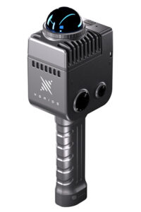 Lixel K1
Field-Ready in Minutes
The Lixel K1 (also known as Lixel Kity K1) by XGRIDS is a compact and powerful mobile mapping scanner. Thanks to its lightweight design of only 1 kg, it can be comfortably handheld even during longer sessions. Whether indoors or outdoors, this LiDAR scanner captures 3D data precisely and efficiently.
The Lixel K1 is equipped with a 360° panoramic camera with a resolution of 2 x 48 MP. It delivers realistic colour imagery that can be used to colourise point clouds and create highly realistic LCC scenes. Its 40-line LiDAR ensures a relative accuracy of up to 1.2 cm and a range of up to 40 m. The Lixel Kity K1 is the ideal choice for users who need fast and accurate 3D data Acquisition.
ASI SKU: 302554
Download Data Sheet
Lixel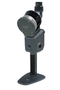 L2 Pro
Real-time scanning and modeling device
The XGRIDS Lixel L2 Pro combines LiDAR, visual, and IMU modules with artificial intelligence to deliver real-time point cloud data. The L2 Pro provides an absolute accuracy of 3 cm and a relative accuracy of 1 cm, enabling the capture of one million points per square meter with a point spacing of just 1 mm. This allows for the creation of extremely precise and dense point clouds, ideal for detailed surveying and mapping tasks. Thanks to a point cloud thickness of only 5 mm, the device is perfect for accurate line drawings and high-precision mapping.
The Lixel L2 Pro features dual 48 MP panoramic imaging without the need for external cameras and, thanks to the LixelUpSample™ algorithm, delivers photo-realistic, colorized point clouds in real time—comparable in quality to post-processed data. With the Lixel L2 Pro 3D scanner, you receive continuous absolute positioning, even in environments with poor signal reception, such as indoors or underground (e.g., subways and tunnels).
ASI SKU: 302498
Download Data Sheet